Water, Garbage & Renewables
TABLE OF CONTENTS:
- Los Angeles Depends on Imported Water
- Garbage Dump, Pollution and Water
- Groundwater Recharge, Retension & Pollution (Water Committee article)
LOS ANGELES DEPENDS ON IMPORTED WATER
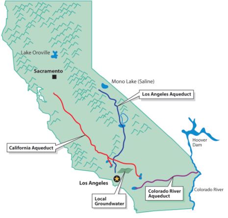
All the places where Los Angeles gets its water
Los Angeles (L.A.) has many ways of getting water and there have been legal water wars started over how much water belongs to thirsty Los Angeles. You can observe the water routes on the above map. Per The River Project, "We currently spend $1 billion a year to import 85 percent of our water supply from other regions whose ecosystems are seriously threatened by that loss." The water comes from the Colorado River and 2 places in Northern California, which are the Eastern Sierras' Los Angeles Aqueducts & San Joaquin Valley route State Water Project. L.A. also gets some of its water from its underground aquifers. The largest one is in the San Fernando Valley but there are pollution issues with this aquifer. The first L.A. Aqueduct involves Mono Lake and the Owens River; the aqueduct goes from those places to LA. The history of how LA got that water isn't very pretty. The LADWP is now reviving, with water, territories near the Eastern Sierra that were devastated by excessive LA water consumption. In California there are heated debates regarding how much water should go to saving our environment, especially the fish population, and what portions should go to farmers and cities. The Sacramento Delta estuary near San Francisco supplies two-thirds of CA's water and it is at the heart of these debates. An estuary is a semi-enclosed coastal body of water with one or more rivers or streams flowing into it, and with a free connection to the open sea. As the fresh water flows into the estuary it acts as a barrier to keep the ocean's salt water from mixing with the fresh water. When the river waters are decreased more salt water blends with the fresh water, which makes it less desirable.
First Los Angeles Aqueduct
William Mulholland is famously associated with the building of the first L.A. Aqueduct. Per Wikipedia, "The project began in 1908 with a budget of US$24.5 million. With 5,000 workers employed for its construction, the Los Angeles Aqueduct was completed in 1913. The aqueduct consists of 223 mi of 12-foot diameter steel pipe, 120 mi of railroad track, two hydroelectric plants, 170 mi of power lines, 240 mi of telephone line, a cement plant, and 500 mi of roads. The aqueduct uses gravity alone to move water and also uses the water to generate electricity, so it is cost-efficient to operate. The construction of the Los Angeles Aqueduct effectively eliminated the Owens Valley as a viable farming community, and devastated the Owens Lake ecosystem. Mulholland and his associates, including L.A. Times Harrison Gray Otis have been criticized for using deceptive tactics to obtain Bureau of Reclamation rights to the Owens River. Mullholland, his associates, and the City of Los Angeles forced farmers off of the land, using violent tactics to intimidate any farmers who refused to sell land to them. In response to these violent tactics, numerous Owens Valley residents sabotaged and destroyed portions of the aqueduct. The aqueduct's water provided developers with the resources to quickly develop the San Fernando Valley and Los Angeles through World War II. San Fernando Valley became part of Los Angeles to obtain these water rights. Mulholland's role in the vision and completion of the aqueduct and the growth of Los Angeles into a large metropolis is recognized and well-documented. First Aqueduct ends at Upper Van Norman Lake (Los Angeles Reservoir) near the I-5 in Granada Hills. There are problems with that area because of the Sunshine Canyon Waste Landfill locating in that area. There will be more on that issue further down in our "Garbage" section."
Mono Lake
(Info. from Wikipedia) By the 1930s, the water requirements for Los Angeles continued to increase. LADWP started buying water rights in the Mono Basin (the next basin to the north of the Owens Valley). An extension to the aqueduct was built, which included such engineering feats as tunneling through the Mono Craters (an active volcanic field.) By 1941, the extension was finished, and water in various creeks was diverted into the aqueduct. To satisfy California water law, LADWP set up a fish hatchery near Mammoth Lake. The diverted creeks had previously fed Mono Lake, an inland body of water with no outlet. Mono Lake served as a vital ecosystem link, where gulls and migratory birds would nest. Because the creeks were diverted, the water level in Mono Lake started to fall, exposing tufa formations (see picture above). The water became more saline and alkaline, threatening the brine shrimp that lived in the lake, as well as the birds that nested on two islands in the lake. Falling water levels started making a land bridge to Negit Island, which allowed predators to feed on bird eggs for the first time.
In 1977 David Gaines & others from Stanford made a report on the ecosystem of Mono Lake that highlighted dangers caused by the water diversion. In 1978, the Mono Lake Committee was formed to protect Mono Lake. The Committee (and the National Audubon Society) sued LADWP in 1979, arguing that the diversions violated the public trust doctrine, which states that navigable bodies of water must be managed for the benefit of all people. The litigation reached the California Supreme Court by 1983, which ruled in favor of the Committee. Further litigation was initiated in 1984, which claimed that LADWP did not comply with the state fishery protection laws.
Eventually, all of the litigation was adjudicated in 1994, by the California State Water Resources Control Board. The SWRCB hearings lasted for 44 days and were conducted by Board Vice-Chair Marc Del Piero acting as the sole Hearing Officer. In that ruling (SWRCB Decision 1631), the SWRCB established significant public trust protection and eco-system restoration standards, and LADWP was required to release water into Mono Lake to raise the lake level 20 feet above the then-current level of 25 feet below the 1941 level. As of 2011, the water level in Mono Lake has risen 13 feet of the required 20 feet. Los Angeles made up for the lost water through state-funded conservation and recycling projects.
Second Los Angeles Aqueduct
(Info. from Wikipedia) The second Los Angeles Aqueduct starts at the Haiwee Reservoir, just south of Owens Lake, running roughly parallel to the first aqueduct. Unlike the original, it does not operate solely via gravity and requires pumping to operate. It carries water 137 mi and merges with the original aqueduct near the Cascades, visibly located on the east side of the Golden State Freeway near the junction of State Route 14. (See a picture of the Cascades under the Garbage section.) Construction cost for the five year project that began in 1965 was US$89 million. In 1970, LADWP completed a second aqueduct. In 1972, the agency began to divert more surface water and pumped groundwater at the rate of several hundred thousand acre-feet a year. Owens Valley springs and seeps dried and disappeared, and groundwater-dependent vegetation began to die. In 1991, Inyo County and the city of Los Angeles signed the Inyo-Los Angeles Long Term Water Agreement, which required that groundwater pumping be managed to avoid significant impacts while providing a reliable water supply for Los Angeles, and in 1997, Inyo County, Los Angeles, the Owens Valley Committee, the Sierra Club, and other concerned parties signed a Memorandum of Understanding that specified terms by which the lower Owens River would be rewatered by June 2003 as partial mitigation for damage to the Owens Valley due to groundwater pumping. In spite of the terms of the Long Term Water Agreement, studies by the Inyo County Water Department have shown that impacts to the valley's groundwater-dependent vegetation, such as alkali meadows, continue. Groundwater pumping continues at a higher rate than the rate at which water recharges the aquifer, resulting in a long-term trend of desertification in the Owens Valley.
The Amazing State Water Project
The Metropolitan Water District (MWD) has tapped Los Angeles into the California State Water Project. (SWP). The SWP's main stem starts from Orville Lake in far No. California to Lake Perris near Riverside in So. CA. It includes facilities that capture, store, and convey water to 29 water agencies. These facilities include: pumping and power plants; reservoirs, lakes, storage tanks; canals, tunnels, and pipelines. In some places they are not only providing water but delivering electricity at the same time. When water is needed, Lake Oroville releases water into the Feather River, which meets up with California's largest waterway, the Sacramento River. The Sacramento River and 4 other rivers then flow into the Sacramento Delta. It is at the Delta where it is pumped by the Banks Pumping Plant into the 444-mile-long California Aqueduct. There are side aqueducts that pump water to water agencies along the way but the main stem flows down-hill through California just by gravity. This section of the California Aqueduct serves both the SWP and the federal Central Valley Project. The water flows through the central San Joaquin Valley farming region. The gravity flow stops at the Edmonston Pumping Plant, where the water is pumped 2000 ft. up over the Tehachapi Mountains to So. California. The west part of the SWP ends at Lake Castaic in the Angeles Forest and the Eastern Part ends at Lake Parris near Riverside in So. California. The SWP provides irrigation water to farms in the San Joaquin Valley, and is a major source of supply for cities in Los Angeles, Riverside, San Bernardino, San Diego, and other parts of southern California
The Sac. Delta's Importance to California
An article in the NY Times says that the Delta area "is so crucial because it provides two-thirds of the state's water supply. Its massive pumping system routes water to cities and farmers alike, but the pumps have drained the delta region and become a kind of killing machine for endangered salmon and smelt. Add to those concerns the likelihood of increased salinity [to our fresh water] as sea levels rise due to climate change, diminished snow pack in the Sierra and the possibility of a major earthquake destroying the delta's maze of 1,100 levees, and you get a perfect storm that could dwarf Hurricane Katrina as a natural disaster." As was mentioned above, when the water gets to So. California it is pumped 2000 ft. up the Tehachapi Mountains to So. California and there are concerns regarding how that pumping system would survive a major earthquake. Because of possible earthquakes in the Delta and to the area near the Tehachapis, we need to rely more on our own local So. California fresh & recycled water supply.
Water Supplies from the Colorado River Aqueduct to Los Angeles
The MWD, also, supplies some of the Colorado River water to L.A. through the 242 mile Colorado River Aqueduct. (Per Wikipedia, the system is composed of two reservoirs, five pumping stations, 63 mi of canals, 92 mi of tunnels, and 84 mi of buried conduit and siphons. Average annual throughput is 1,200,000 acre·ft. With the droughts in the west, the amount of water that Los Angeles is allowed could dwindle, so we need to provide local fresh & recycled water in its place.
GARBAGE DUMP, POLLUTION AND WATER
Timeline for Sunshine Canyon Landfill
Both the L.A. City & County owned land in Sunshine Canyon
1991 Old City Dump was closed.
1996 County expansion opened in 1996
1999 City passed the expansion & reopening of the Sunshine Canyon Landfill on the city side. It actually opened in 2005
2009 the County and City landfill were combined
Information from Wayde Hunter, president of the North Valley Coalition website.
Contributer: Elaine Trogman, editor of Sierra Club, SFV website.
Granada Hills is a section of L.A. that is near the Sunshine Canyon Landfill and they feel they have done more than their share of housing L.A. City's garbage. There are Granada Hills' houses whose next door neighbor is the dump. They feel other parts of the city should take responsibility for waste, also. The old City dump was here, in one form or another, for thirty-five years and the City promised "valuable recreational land" on the site when it closed in 1991. The County expansion, which opened in 1996, was further away from the community. On 12/08/99, our L.A. City Council passed their expansion, and the reopening of the Sunshine Canyon Landfill on the City side, despite the danger to the air, water, families, and natural resources of all of Los Angeles! This was done despite alternatives such as rail haul to other remote sites, and better recycling programs. The approvals also included the provision to combine the County side landfill and to provide additional space to the tune of 90,000,000 tons. The landfill was combined into one landfill in 2009, which has made it the largest dump in the USA. With the City expansion opening in 2005 and the combining of the City and County sides in 2009 the bulk of the operations are now much nearer to neighborhoods. The dump is operating in the lowest part of a very deep canyon, a mile away from the entrance. Impacts will increase as operations move higher and when more methane gas is generated by the waste pile. As was mentioned, it would be much fairer if each district could come up with a plan for disposing of its own waste. The landfills would be smaller than one great huge landfill and the pollution would be more manageable.
Air Quality & Other Toxics With the combining of the City and County landfills the daily operations have moved ever closer to homes and the neighbors are now experiencing more and more odor complaints from residents. In 2011 the number of reported odor problems caused by Sunshine Canyon Landfill was 10 times worse than all of the other 15 landfills "combined" within the South Coast Air Quality Management District's (SCAQMD) oversight. In fact 20% of all the calls to the SCAQMD for any reason that year were from Granada Hills about the landfill. Damaging landfill gas, such as methane, is released from decomposing waste in the landfill; to stop this gas from being released into the atmosphere flares are used to burn the gas. At least 351 tons per day of emissions are released from the three existing flares not counting any surface emissions. A fourth flare is under construction with a fifth flare starting the permitting process. There will be at least 2,600 truck trips per day, delivering trash to the dump. The North Valley Coalition was able to get the County Supervisors to agree that Sunshine would not take any garbage that was not produced in LA County. Most of the trash will come from the City of Los Angeles, but much of the trash will come from many other cities in Los Angeles County that have been collected by past owner BFI and the dump's new owners."
The air impacts, which cannot be mitigated, causes health problems such as cancer, birth defects, lung damage, immune system damage, and nerve damage. This is due to the relationship between air toxic pollutants (known or suspected) generated by diesel emissions from trucks, the outgassing of methane at the surface of the landfill, as well as particulate emissions of PM2 and PM1O caused by the flaring of the methane. The most impacted by these toxics are the young, pregnant women, and the elderly. A landfill such as Sunshine Canyon can be expected to generate 20,000,000 to 40,000,000 cubic feet of methane gas a day as it fills. Plans and permits have been approved for a Gas-to-Energy plant to be constructed and operational in the next two years. Unfortunately for the neighbors, this plant which will generate electricity from the methane gas diverted from some of the flares will produce more PM2 and PM10 than the existing flares. The dump will continue to receive up to 66.000 tons of commercial, industrial, and household wastes each week, including sewer products and contaminated soil. It is estimated that over 300 tons of this weekly inflow will be toxic or hazardous. There is no way to mitigate the degradation of the air quality -- this is according to the previous owner BFI's own experts, the Los Angeles Unified School District, the AQMD, and other agencies. Children are in danger, according to the Board of Education City of Los Angeles, the Los Angeles Unified School District, the South Coast Air Quality Management District, and some members of the Los Angeles City Council.
Earthquake issues The dump site is in a seismic-hazard area, within an Alquist-Priolo Study Zone (Seismic and Earth Movement) located next to the Santa Susana fault line, in a geologically unstable area. There will be continued movement potentially causing tears in the dump liner system and compromising its leachate collection system. Leachate is water that is in contact with decomposing solid waste, the percolating water becomes contaminated and if it then flows out of the waste material it is termed leachate. Several earthquakes have been recorded within the dump most notably in 1971 & 1994. Landslides are a common occurrence. The landfill operators themselves have caused several massive landslides internally over the years which have resulted in the abandonment of the Countyside leachate treatment plant, weight scales, and access road.
There were safer places for the dump. At the hearing for the City's 5-year trash disposal contract, several competitors of BFI came in with estimates that were less than BFI to haul the trash away to areas that would not be impacted by the refuse or the particulate and diesel emissions. This would cost (by the City's own admission at that time) 50 cents per person per month in Los Angeles City. Remember that these were high estimates and that the City was refusing to ask for bids! The City wanted this dump for revenue purposes and franchise fees it would generate. The City was the responsible agency for investigating the validity and the safety of the SEIR (Subsequent Environmental Impact Report). The City abdicated this responsibility to consultants hired by BFI, and have never verified the results!
The City tore out nearly 1000 oak trees alone, and destroyed streams and acres of wetlands in order to put in this dump, as well as ruining the habitat for many species of wildlife. The partial total of the destruction so far when combined with the Countyside of the landfill amounts to over 6000 mature oaks, 20,000 other trees including black walnut, and spruce, and 12 acres of wetland.
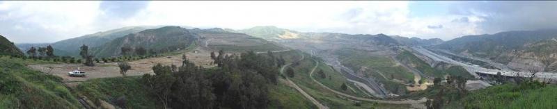
We have just discussed the water that has been imported from far-away places into the L.A. area. This imported water flows through the general area in the picture above, and in the picture below where there are many other water treatment facilities located together in the middle of the picture.
In the picture above which looks northwest it is obvious that there is a large freeway section of the I-5 between the I-14 and 210 Interchanges (to the right), and the biggest landfill in the USA, the Sunshine Canyon Landfill (to the left of the freeway and in the fore ground). What you can’t see in this picture is that the main water treatment plant for this imported water is nearby and to the southeast. This facility purifies the water and then sends it to the L.A. Reservoir for storage until it is used for drinking water at your house. (See picture of reservoir & dump below.) This is a poorly planned and unhealthy situation. We need to have the dump far away from this main important, imported water source—not practically next door as it is now. To make matters worse this is a high earthquake area.
Note: Editor Elaine took a tour of the Los Angeles Aqueduct Filtration Plant [LAAFP] and a 3-mile walk around the L.A. Reservoir, where the water goes after leaving the filtration plant. Currently at the Los Angeles Aqueduct Filtration Plant (LAAFP), the disinfection requirements are met through a combination of ozone, filtration, and chlorine treatments. There will be an addition of an ultra violet (UV) light treatment facility at the LAAFP; the operational date is March of 2014. This UV facility is being constructed to treat the water following the filtration process and before it is released into the L.A. Reservoir. The addition of this UV facility will help to reduce the formation of byproducts by providing pathogen disinfection while allowing for reduced use of ozone and chlorine. Low doses of UV are required to disinfect the water of Giardia lambia and cryptosporidium while not producing any known by products. Chlorine will continue to be used to achieve virus disinfection. The final treatment step will then be the injection of ammonia into the water to combine with the Chlorine and form the chloramine residual. The leader of the tour mentioned that this Chloramine last step is going to be used to counteract the negative health effects of Chlorine. (The information about the process has been obtained from the LADWP website. See more information by clicking this link.
There is a legal requirement to cover all reservoirs but the L.A. Reservoir is too big to have a constructed roof on top of its waters. Instead, they are already in the process of covering the complete water surface with black plastic balls. As of 7-26-13 the reservoir was about 1/3 to maybe ½ covered with the black balls.
With this latest expansion, the Sunshine Canyon Landfill is the largest dump in the United States, near the largest water supplier in the United States (LA Dept. of Water & Power (LADWP) & Metropolitan Water District), providing water for 19,000,000 people living in Los Angeles and surrounding counties. The dump is near the LADWP reservoir which holds our treated drinking water! The landfill is within 500 feet of an already earthquake damaged tunnel that carries the LADWP’s water from the California Aqueduct to its water treatment plant, and potentially contaminated waters exiting the landfill discharges to the County Flood Control channel which passes directly over it.
Winds in the area have been clocked in excess of 100 miles an hour; these winds carry pathogens from the dump into our water supply. The black plastic balls can help cover the L.A. Reservoir but they aren’t as impenetrable as a roof; toxic chemical and human wastes can potentially contaminate birds that wander through the trash looking for food. The birds can then go back to the reservoir to rest and defecate. Some of these negative effects will be controlled by a last cleaning when the water gets to its last distribution point before going to your faucet, but having the water supply next to the dump is still a bad situation. This dump is slowly polluting the groundwater through unlined sections of the old City landfill, and potentially any leakage from under the County landfill whose single liner system started leaking only six years after it was installed. In the 1999 City Council hearing when the dump was voted in, BFI admitted to problems in one of its test wells.
There is a marker near these "Cascades" that reads: "The Los Angeles Aqueduct Cascade. California Historical Marker No. 653 Cascades - This is the terminus of the Los Angeles - Owens River Aqueduct, which brings water 338 miles from the eastern slopes of the Sierra Nevada to the City of Los Angeles."
If you were to look at a map of the area near the Sunshine Landfill you would see that a variety of Los Angeles' water purification and storage facilities are near the Sunshine Waste Landfill. This is very poor planning and an unhealthy situation. This link is to a photo of the area with explanations:
The photo map shows the following facilities close together from North to South. (Sunshine Canyon Landfill is furthest north & Lower Van Norman dam is the furthest south.)
Sunshine Canyon Landfill
Los Angeles Aqueduct Filtration Plant (MWD Jensen Filtration Plant)
Upper Van Norman Lake Basin
City of Los Angeles Water Treatment Plant
Los Angeles Reservoir
Los Angeles Dam
1971 Earthquake damage Lower Van Norman dam site
Lower Van Norman Dam