Update on the Whittier Narrows Dam Safety Modifications
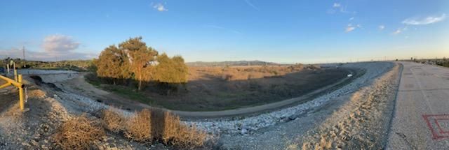
The Whittier Narrows Dam is an earthen dam constructed in 1957 by the United States Army Corps of Engineers. The dam stretches across a narrow gap between the Montebello Hills and the Whittier Hills at the confluence of the Rio Hondo and San Gabriel Rivers. Rosemead Boulevard (California State Route 19) crosses over the top of the dam and passes through the flood plain bordered by both rivers. The main purpose of the dam is to provide flood protection to more than 1.2 million people living in communities below the dam while also capturing storm water for groundwater recharge.
Plans to deepen and increase the storage capacity of the Rio Hondo Conservation Pool behind the Montebello portion of the dam were put on hold when significant safety risks were discovered. According to the Army Corps of Engineers’ Whittier Narrows Dam Safety Modification Plan:
In January 2024 the Army Corps of Engineers hosted a tour of the dam for the commander of the U.S. Army Corps of Engineers South Pacific Division. The press release provided an update on the safety modification work completed to date:
‘The Whittier Narrows Dam Safety Modification Study was completed in June 2019, and work has begun to address those deficiencies. Issues with the San Gabriel River spillway gates have already been addressed, which was one of the biggest factors driving the dam’s risk to the public, Smith said.
Remaining work includes placing soil cement on the crest and downstream slope of the embankment to protect against erosion and failure if overtopped and installing graded filter/drainage blankets and trench drains to control seepage. Minor construction started in 2021, with larger construction contracts to be awarded in 2025 after completion of design work. Major work is expected to take between four and five years to complete.’
Flood danger to motorists and pedestrians
On February 27, 2024, the Los Angeles County Board of Supervisors adopted an agreement between the County and the Army Corps of Engineers. The agreement provides more details on the proposed improvements to the dam, including modifications to Rosemead Blvd., and other roadways impacted by the dam.
Key project features include raising the dam spillway elevation to prevent overtopping, constructing drainage improvements within the Corps property, within the County of Los Angeles unincorporated area raising Rosemead Boulevard 6 feet, and within the City of Montebello raising Lincoln Avenue 6 feet and realigning Lincoln Avenue southward 60 feet. The Corps project will impact facilities under the jurisdiction of the Los Angeles County and the Los Angeles County Flood Control District (District), including Rosemead Boulevard owned and operated by Los Angeles County Public Works and a 78-inch storm drain (referred to as Poplink) owned and operated by the District.
The agreement also states:
“The Corps would relocate the roadway at no construction cost to the County.”
Source link: https://file.lacounty.gov/SDSInter/bos/supdocs/188692.pdf
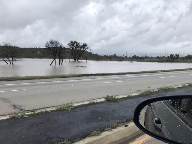
Feb. 2019. Rosemead Blvd just above the Whittier Narrows Dam during a large storm event. The flood waters in the dam on both sides of the roadway came dangerously close to overtopping Rosemead Boulevard. The cross streets at San Gabriel Blvd (to the left of this photo) and Durfee Avenue (not pictured) were completely submerged.
Photo credit: Yvonne Martinez Watson
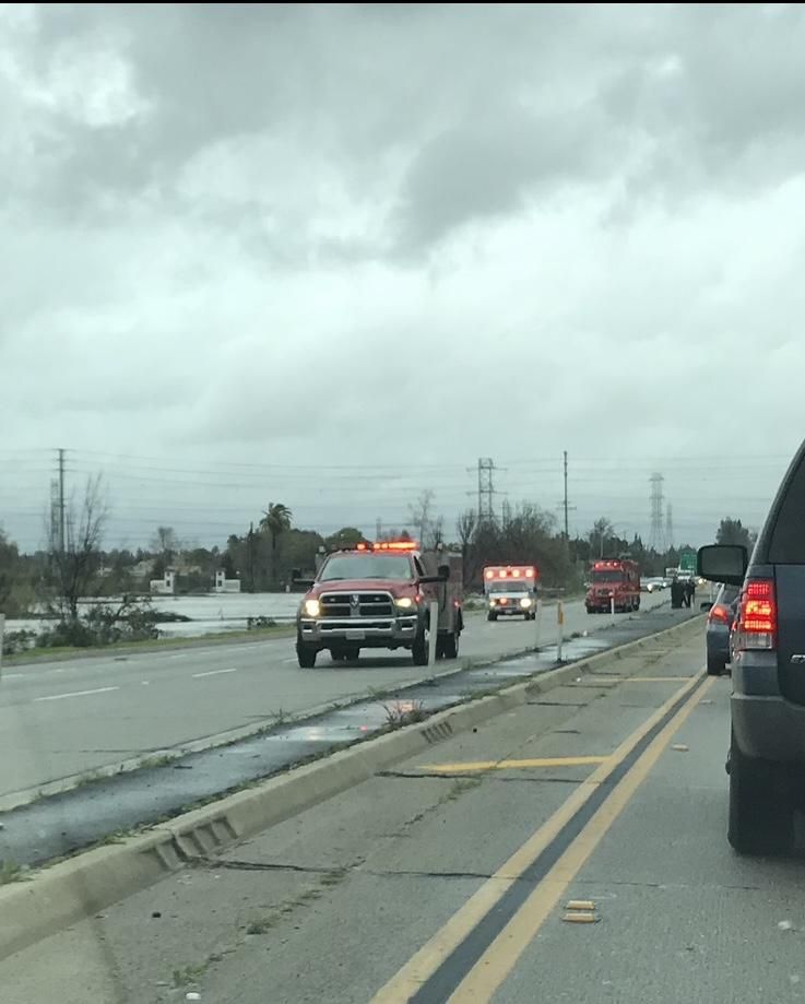
Feb. 2019. A swift water rescue was being conducted in the adjacent Whittier Narrows Park area while traffic was waiting to be redirected out of the danger zone. These photos were taken from a car that was one of the last to enter the area before Rosemead Blvd. was closed. Due to the rise in elevation while crossing over the dam the danger was not visible from the Pico Rivera (south) side of the dam. Photo credit: Yvonne Martinez Watson
Our Ask
The frequency and fury of atmospheric river generated storms such as the ones California recently experienced has increased due to climate change and the risks posed to travelers and residents will remain high until the Whittier Narrows Dam Safety Modification Project has been completed.
Please urge your state representatives to ask for more funding and an expedited repair schedule of the dam to safeguard the lives of all those who live, travel and play within its shadows.
For More Information
The Draft supplemental environmental assessment: Whittier Narrows Dam Safety Modification Project can be read at the following link:
https://usace.contentdm.oclc.org/digital/collection/p16021coll7/id/22967
Yvonne is a long time member of the Angeles Chapter Water Committee and the Chair of the Angeles Chapter Environmental & Social Justice Committee.
Add new comment