What do you think of the Rim of the Valley Corridor plan?
Southern California currently has a patch work of national, state, county and city parks and trails that mostly didn’t exist before the 1970s. A plan has been afoot for some time to join them together to protect wildlife, open space, water supply, cultural assets and more.
The Rim of the Valley Corridor would include the mountains encircling the San Fernando, La Crescenta, Santa Clarita, Simi and Conejo valleys. And the question is this: Are areas of the Rim of the Valley Corridor nationally significant, suitable, and feasible for inclusion in the national park system? And should portions of the corridor be eligible for inclusion in Santa Monica Mountains National Recreation Area?
The National Park Service is seeking comments until June 30 on a study for this proposed corridor, and we urge you to respond. Click here for information on the project and how to comment.
For the moment, the major federally protected areas are the Santa Monica Mountain National Recreation Area outlined in green on the southwest portion of the map and the Angeles National Forest over to the northeast portion of the map. Part of the newly created San Gabriel Mountains National Monument is in the Angeles National Forest. These lands comprise approximately half of the study area.
The majority of the lands in the study area (approximately 84%) are undeveloped open space or areas protected for conservation and recreation purposes. The study area is roughly 50% privately owned lands and 50% public lands. Portions of at least 30 communities are located in the study area, with approximately 5.1 million residents. The study area covers more than 1,000 square miles (650,000 acres.)
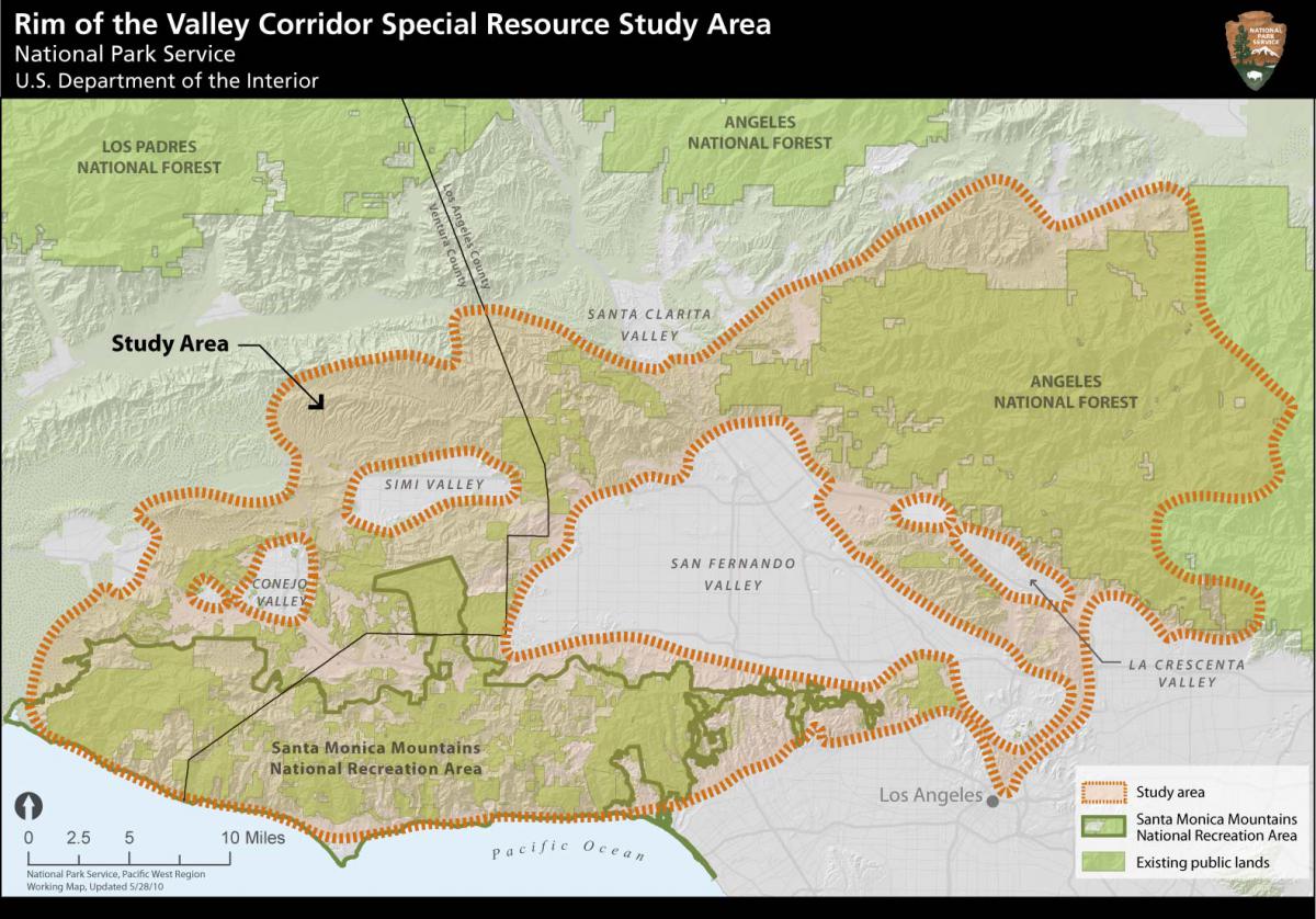
Of the 650,000 acres studied, approximately one-quarter (or about 153,000 acres) is within the existing boundary of the Santa Monica Mountains National Recreation Area. The federal parkland protects the largest expanse of mainland Mediterranean ecosystem in the national park system. No other national park features such a diverse assemblage of natural, cultural, scenic, and recreational resources within easy reach of a population of more than 18 million.
For more than 30 years, the National Park Service has managed the Santa Monica Mountains area through a unique partnership in which the federal government works collaboratively with state and local park agencies as well as private landowners to protect the natural and cultural resources of the area. Within the recreation area, the Park Service directly owns and manages more than 23,000 acres, or 15% of the 153,000 acres within its boundary. The Park Service preliminarily determined that a boundary expansion of the recreation area would be less costly and more efficient than establishment of a new stand-alone park area.
The alternatives
The study team developed four alternatives based on information gathered at public meetings, international Park Service discussions, evaluation of existing studies, historical research and management models.
Alternative A: Continuation of Current Management (No Action) serves as a baseline for evaluating the action alternatives.
Alternative B: Cooperative Conservation Partnership would foster cooperative planning and funding tools for the National Park Service, partner agencies and landowners in the study area and conserve key habitat linkages to the Los Padres and Angeles national forests.
Alternative C: Rim of the Valley Boundary Adjustment (the Preferred Alternative by the National Park Service team) includes a Santa Monica Mountains National Recreation Area boundary adjustment (approximately 173,000-acre addition) that would provide more recreational opportunities.
Alternative D: Regional Rim of the Valley Boundary Adjustment and Cooperative Conservation Areas Includes a Santa Monica Mountains National Recreation Area boundary adjustment (approximately 313,000-acre addition) with an emphasis on protecting regional wildlife corridors that would include most areas within the Rim of the Valley Corridor (excluding U.S. Forest Service managed areas). Cooperative conservation approaches are recommended for key habitat linkages between the Rim of the Valley Corridor study area and the Los Padres and Angeles national forests.
Download an abstract of the Rim of the Valley Corridor Special Resource Study.
Details can be found at the Rim of the Valley Corridor Special Resource Study website.

Add new comment