What's included in the new San Gabriel Mountains National Monument?
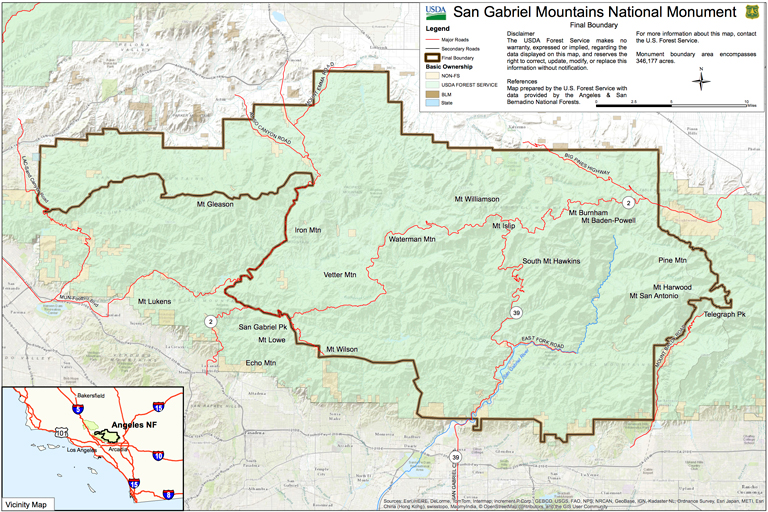 |
| The dark lines within the green show the boundaries of the newly created San Gabriel Mountains National Monument. Source: WhiteHouse.gov |
The select status conferred on much of the San Gabriel Mountains by President Obama’s designation of a San Gabriels National Monument sets the stage for welcome changes. They would include protecting the environment while improving the recreational experience for its many visitors in the rugged range that frames the northern skyline for the Los Angeles region.
Obama stressed the mountains’ importance in the first few sentences of his October 10 proclamation designating 346,177 acres, a little more than half of Angeles National Forest, as a national monument:
"Over 15 million people live within 90 minutes of this island of green, which provides 70% of the open space for Angelenos and 30% of their drinking water. Millions recreate and rejuvenate in the San Gabriels each year, seeking out their cool streams and canyons during the hot summer months, their snowcapped mountains in the winter, and their trail system and historic sites throughout the year.”
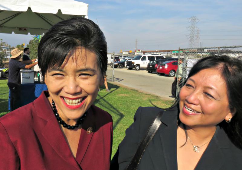 |
| Rep. Judy Chu, left, and Sierra Club national board member Susana Reyes. Credit: John Monsen |
Speaking to about 200 invited guests at Frank G. Bonelli Regional Park in San Dimas, Obama said, “It’s not enough to have this awesome natural wonder within your sight. You have to be able to access it… We’ll keep working with you to make sure that everybody in this diverse community, no matter where they come from or what language they speak can enjoy all that this monument has to offer.”
Crowds of people seeking to enjoy the mountains -- picnicking, hiking, cycling, wading in streams -- have often overwhelmed popular recreation areas. The underfunded U.S. Forest Service spends the majority of its budget on firefighting. Crowding, trash, graffiti and vandalism are persistent problems. More recreational facilities and uniformed rangers to patrol popular areas are needed, especially along the San Gabriel River north of Azusa.
The $4.5 million in promised additional funding will help, including $3 million pledged by the National Forest Foundation, $500,000 by several foundations, and $1 million by the U.S. Forest Service. Donors said their money will be channeled into restoration and habitat improvement, community priorities and stewardship, visitor centers and other facilities, maintenance work on trails and picnic areas, and additional education staff.
Sierra Club members who use the mountain trails for hundreds of hikes every year can help in various ways to achieve the monument’s objectives of preserving and protecting the forest and improving the recreational experience:
Perform volunteer work. Trails need constant maintenance and minor repairs to trim back brush, restore a usable tread where dirt has slid down a hillside across the trail, and remove downed trees and limbs. The Sierra Club’s Trail Crew has been working since shortly after the 2009 Station Fire on several trails, including the Strawberry Peak and Colby Canyon Trails, and the Rim Trail near Mt. Wilson. Volunteers might also help at picnic areas and visitor centers.
Participate in shaping the management plan. The President’s monument proclamation directed the Secretary of Agriculture, parent agency of the U.S. Forest Service, to prepare a management plan within three years, with “maximum public involvement… including, but not limited to, consultation with tribal, State, and local government, as well as community environmental conservation, health, and justice organizations.” The secretary of Agriculture is to consult with the Secretary of Interior, but final decisions on plans and regulations rest with the Secretary of Agriculture and Forest Service. Environmentalists will want to attend any hearings, suggest improvements and challenge undesirable changes.
Use Sierra Club hikes to inform hikers of the monument’s potential. Take a few minutes at the trailhead to mention its implications for future preservation and recreation, and the opportunities for volunteers. If the hike crosses a border of the monument, or one of the Angeles Forest’s four wilderness areas, mention the meaning of those designations.
What these wildlands are like
The monument area includes peaks, canyons and streams that are home to rare and endangerd species, including Nelson bighorn sheep and mountain yellow legged frogs as well as bears, mountain lions and other animals and birds. Historic features include Native American artifacts, and the Mt. Wilson Observatory. Obama, citing these features, used his powers under the 1906 Antiquities Act to designate the national monument. It was his 13th designation, involving a total of about 3 million acres, he said, adding, “And I’m not finished.”
Efforts to focus more resources on the San Gabriels began in 2003 as a bill by then Rep. Hilda Solis directing the National Park Service to study the area for possible National Park Service status. Her successor, Rep. Judy Chu, took over the effort and the Park Service held community hearings in 2012 and 2013. Chu met with elected officials, water agency leaders, and environmental groups to gain support.
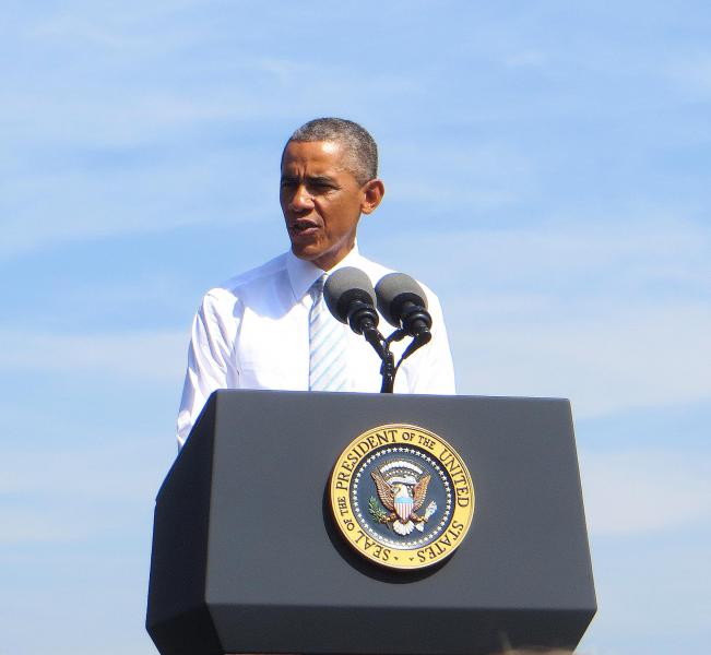 |
| President Obama speaks at the monument's creation in San Dimas. Credit: Don Bremner |
Chu introduced a bill in Congress last June that would create a San Gabriels National Recreation Area to include much of Angeles National Forest, as well as communities downstream along the San Gabriel River that flows out of the mountains at Azusa. Under this plan, various cities, the county and the federal government would continue to own and manage their lands while cooperating to improve recreation and education, helped by funds and personnel of the National Park Service.
With the NRA bill stalled in a highly partisan, divided Congress, Chu turned to the Obama Administration for a monument designation. Since only federal lands can be designated a national monument, the downstream areas along the San Gabriel River were not included. And because of objections from San Bernardino County supervisors and others, Mount Baldy, the Mt. Baldy ski area, and Cucamonga Canyon were left out of the monument.
What's not included in the new monument
Surprisingly, a large area in the southwest part of Angeles National Forest also was left out of the monument. Much of the national forest hillsides seen from Sierra Madre, Pasadena, Altadena, La Canada Flintridge, La Crescenta and Glendale are not in the monument. Mt. Lukens, Mt. Gleason, Condor Peak and Big Tujunga Canyon, are omitted.
The Arroyo Seco from its origin near Red Box to where it emerges from the national forest into Pasadena’s Hahamongna Watershed Park also is outside the monument. All of the Arroyo Seco’s watershed in the mountains was burned in the 2009 Station Fire, and the ensuing rains and mudflows from denuded hillsides severely damaged the arroyo and parts of the Gabrielino Trail in it. Excluding it from the monument means it won’t benefit from any added resources the monument brings.
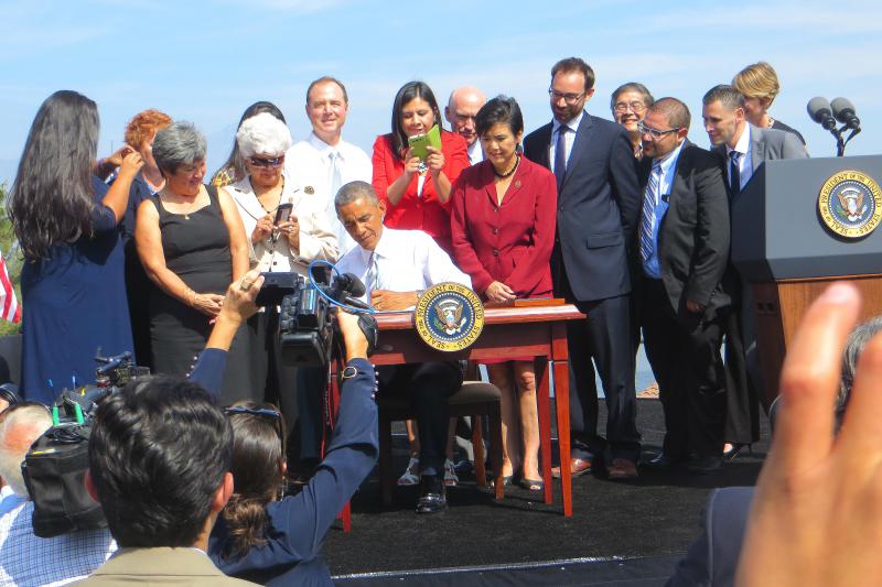 |
| Activists and elected officials join the president as he signs the Antiquities Act designation. Credit: Don Bremner |
Asked why this large southwestern area covering much of the national forest burned in the devastating Station Fire was left out of the monument, sources said the Administration anticipated legal challenges to the monument designation, and wanted to minimize the risk by excluding the Los Angeles River basin. The Arroyo Seco joins the Los Angeles River near Dodger Stadium.
Still, many monument supporters who had worked over the years for more resources for the forest were delighted with the president’s action. As one said, “We’ll take half a loaf -- or two-thirds of a loaf.”
Efforts continue to designate an additional 120,000 acres of wilderness across the San Gabriel range, said Angeles Chapter Forest Committee Co-Chair John Monsen. This includes the 18,000-acre Condor Peak proposed wilderness area north of Sunland-Tujunga and Mt. Lukens less than 10 miles as the crow (or condor) flies from La Crescenta and La Canada in the area omitted from the new National Monument.
Don Bremner is co-chair of the Angeles Chapter’s Forest Committee.

Add new comment